Innovation snapshot
Nautiloc is a buoy-based GPS tracking system developed to follow the movement of floating litter in seas and rivers. In the REMEDIES context, the buoys are designed to replicate common plastic litter items, such as bottles and boxes, and to generate continuous drift data that can support targeted clean-up, prevention planning, research and public awareness.
Related REMEDIES pillars: Detection & Monitoring; Prevention & Zero-Waste Solution
Partner(s)/Owner(s): MCGREECE
Made for: Researchers, environmental agencies, local authorities, marine companies, transportation businesses, fishermen, divers, water sports users and other users who need object tracking in marine or land environments.
Technology maturity: Field-deployed demonstrator / pilot / prototype validated through REMEDIES deployments in rivers, straits, island corridors and coastal waters.
Commercial relevance: Designed for organisations that need long-duration, real-time tracking of floating objects, plastic litter pathways and potential accumulation hotspots.
Watch the related REMEDIES Cyclades Demo Site video:
The challenge it addresses
Plastic litter does not move in a straight or predictable way. Its route is shaped by currents, wind, waves, river discharge, island geomorphology, straits, coastal activities and seasonality. This makes it difficult for public authorities, researchers and clean-up actors to know where plastic will accumulate, when to intervene, and which areas should be prioritised.
- Unpredictable litter movement: floating plastics can travel long distances, reverse direction or become trapped in local retention zones.
- Weak hotspot intelligence: without high-resolution drift data, clean-up and prevention actions are often reactive rather than targeted.
- Limited source-to-sink evidence: rivers, ferries, tourism zones and coastal activities can all contribute to plastic leakage, but the pathways are difficult to document.
- Public interaction risks: visible tracking devices can be removed by swimmers, tourists or fishermen if the purpose is not understood, interrupting data collection.
The solution: Nautiloc
Nautiloc combines a floating buoy casing with a compact GPS tracker. The device is deployed in selected river and marine locations and transmits its position through an online GPS platform. In REMEDIES, the devices were used to simulate how floating litter travels, where it becomes trapped, and which routes connect rivers, islands, straits and open marine corridors.
- Tracks floating litter movement in rivers, estuaries, straits and coastal waters.
- Supports detection of plastic accumulation zones and dynamic hotspots.
- Provides evidence for targeted clean-up operations, policy design and prevention strategies.
- Connects GPS drift data with the REMEDIES Portal, enabling visualisation, statistics and monitoring of buoy behaviour.
From prototype to field-ready design
The technology evolved through practical testing. Early casing designs explored cork and several wood options. Cork was rejected because of moisture sensitivity. Wooden prototypes were tested for buoyancy, durability and GPS signal reliability, but field experience showed that weight, water ingress and degradation could affect performance. The final approach moved toward plastic buoy casings, including LDPE/LHDPE-type material, to improve buoyancy, durability and data reliability while keeping the device light enough to behave more like floating plastic litter.
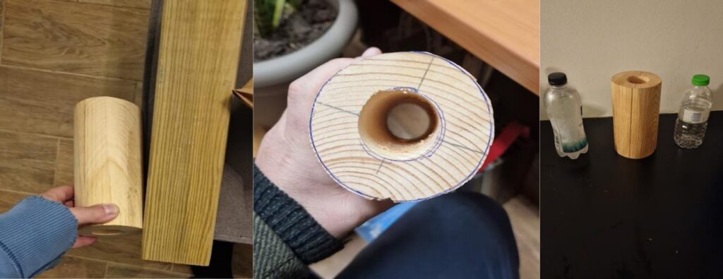 Construction of buoys with cylindrical shape (Source: MCG; protocol Figure 19)
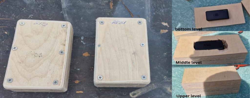 Construction of buoys with GPS with rectangular shape (Source: MCG; protocol Figure 20)
The product design also had to protect the GPS device while maintaining correct orientation in the water. Early models included a dedicated slot for the tracker and external programme labels. Later, external identifiers were reduced because highly visible labels made the devices attractive to passers-by and increased the risk of unplanned retrieval.
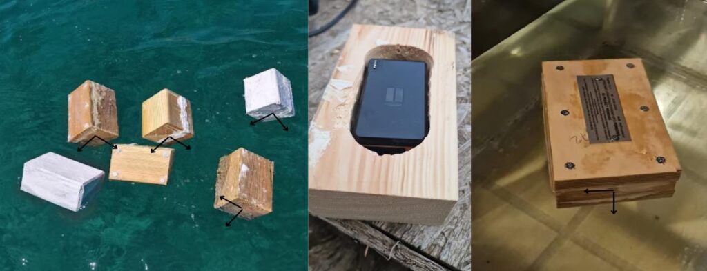 Buoys with GPS first test into water (Source: MCG; protocol Figure 21)
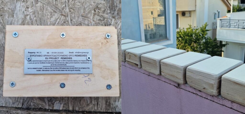 Remedies Label on a buoy (Source: MCG; protocol Figure 22)
Unique value proposition
- Real-time drift intelligence: provides location data that helps users understand how floating objects move through marine and river systems.
- Plastic hotspot detection: supports identification of areas where litter accumulates or becomes trapped.
- Field-tested design: the buoy casing and GPS selection were refined through deployments in ports, rivers, island corridors and open-sea conditions.
- Long-duration tracking: the innovation profile presents the device as compact, waterproof and suitable for long-term tracking, with positions recorded every 12 hours through an online platform.
- Operational decision support: trajectories can be used to plan clean-ups, support prevention measures and build evidence for policy and environmental management.
- Public engagement value: the movement of visible, trackable devices makes plastic pollution pathways easier to explain to communities, media and decision-makers.
Technical characteristics
- Buoy-based GPS tracking system designed for marine and river environments.
- GPS tracker size range presented in the REMEDIES innovation profile: 4 to 8 cm.
- GPS tracker weight range presented in the REMEDIES innovation profile: 80 to 140 g.
- Battery capacity presented in the innovation profile: 6600 mAh, with long-duration operation for extended monitoring campaigns.
- Waterproofing presented in the innovation profile: IP67 certification.
- GPS positions can be accessed through a web platform and Android / iOS applications.
- The REMEDIES Portal integrates buoy position data, dropping locations, distance travelled, average speed, animated maps, KPIs and trapped-device alerts.
Who can use it
- Research institutions and environmental agencies that need evidence on plastic drift, source-to-sink pathways and hotspots.
- Local authorities and coastal managers planning targeted clean-up, prevention and mitigation actions.
- NGOs and citizen science initiatives that want to communicate the movement of floating litter through tangible field evidence.
- Marine companies and transportation businesses that need object or asset tracking in marine environments.
- Fishermen, divers, water sports users and field teams that can benefit from compact tracking devices for safety, recovery or monitoring.
Deployment and exploitation pathway
Nautiloc is positioned as a scalable environmental tracking solution with both public-interest and commercial applications. Its value is strongest where decision-makers need to move from general awareness of plastic pollution to precise, location-based action.
- Research collaborations with universities, environmental organisations and marine institutes to expand drift modelling and hotspot analysis.
- Integration with clean-up strategies, enabling NGOs and authorities to target the right locations at the right time.
- Commercial tracking applications for marine companies, transport operators and asset-monitoring users.
- Rental and short-term monitoring services for projects that need temporary deployments without purchasing a full fleet.
- Public awareness campaigns using real drift data to show how plastic pollution travels across river and marine systems.
Discover more and contact
MCGREECE: https://www.mcgreece.gr
Contact for further information: info@remedies.com